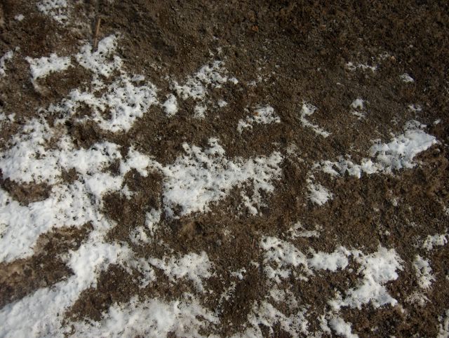
Tämä kuva päättää viiden kuvan sarjan, jossa on tarkasteltuna auringonsäteilyn aikaansaamia sulamiskuvioita lumipinnoilla samana päivänä. Kuvien tilanteessa Suomen itäpuolelle oli voimistunut luoteesta matalapaine ja sen myötä pohjoisesta oli virrannut uudestaan pakkasilmaa (ylin lämpötila -2,1 astetta ko. päivänä) ja edellisenä päivänä kylmenemisen yhteydessä oli satanut ohuesti uutta lunta. Tässä vanha lumi oli erityisen likaista suuren hiekkamäärän vuoksi ja niinpä sen ja uuden lumen kontrasti oli voimakas. Maaliskuun aikana tapahtuneen sulamisen takia vanhan lumen seassa olleet muut ainekset olivat tyypillisesti tulleet yhä enemmän esille lumen vähennyttyä ja siksi tuo vanha aurattu lumikasa alkoi olla nyt lähinnä kasa hiekkaa ainakin pinnaltaan. Säätilanne: valitse 20.3.2006; Wetter3 A. Wetter3 B.
This picture ends the five picture series, where the melting patterns on snowsurfaces caused by the radiation of the sun are observed during the same day. In the situations of the photos a low pressure had been strengthened from the northwest to the easternside of Finland and due to that frosty air (the maximum temperature -2,1 C in this day) had been flowed again from the north and during the previous day it had been snowed thinly when it became colder. In here the old snow was especially dirty due to a big amount of sand and therefore the contrast between it and the new snow was strong. During March due to the melting the other matters among the snow had been exposed further more when the snow had been decreased and that's why that old plowed snow started to be now mainly a pile of sand at least on the surface. Weather condition: choose 20.3.2006; Wetter3 A. Wetter3 B.
Helsingin Puistolan säätilasto maaliskuussa 2006 - Weather chart of Puistola, Helsinki in March 2006.
Flickr 1 Flickr 2

posted by Mika at 11:51 AM
![]()


0 Comments:
Post a Comment
<< Home