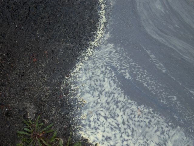
Kuun kahden ensimmäisen päivän aikana etelästä saapuneen matalapaineen sadealue ohitti niin Espoon Tapiolan kuin Hämeenlinnankin itäpuolitse. Kuvauspäivänä lännestä saapunut sadealue antoi sadetta molemmille alueille. Sadealue liittyi Lappiin lännestä saapuneeseen matalapaineeseen. Ilma oli kahtena edellisenä päivänä melko lämmintä ylimpien lämpötilojen oltua Etelä-Suomessa n. +20 astetta. Kuvauspäivänä iltapäivän lämpötila jäi kuitenkin vain n. +10 asteeseen sateisen sään ja lännestä virranneen ilmamassan takia. Tässä kuvassa nähdään sateen aiheuttamassa lätäkössä siitepölyä asfaltin pinnalla voikukan (Taraxacum officinalis) lehtien kera. Tämä siitepöly oli tällä kertaa peräisin Suomen kahdesta yleisimmästä puulajista; metsäkuusesta (Picea abies) ja metsämännystä (Pinus sylvestris). Niiden molempien kukinta-aika oli edelleen menossa ja tämä kasvukauden vaihe oli suunnilleen tavanomainen ajankohtaan nähden. Ko. puiden siitepöly on sen verran isokokoista ja sitä muodostuu tuulen vietäväksi kerralla niin runsaasti, että sitä laskeutuu kaikille pinnoille näennäisesti huomattavia määriä. Sateen sattuessa ko. aikana kaikki vesipinnat ovat usein kuvan tilannetta paljon runsaamminkin keltaista massaa täynnä. Myös kuivana aikana ennen sadetta eri pinnoilla voidaan nähdä tasainen kerros tätä keltaista pölyä. Kuvassa nähtävä tilanne oli kaikkialla Etelä-Suomessa erittäin tyypillinen ko. päivänä. Kuva on otettu Hämeenlinnassa. Säätilanne: valitse Base Time 3.6.2006. Wetter3 A. Wetter3 B.
During the first two days of the month a precipitation area of a low pressure arrived from the south passed both the district of Tapiola in Espoo and Hämeenlinna from the eastern side. In the photoshooting day a precipitation area arrived from the west brought rain into both places. The precipitation area was associated with a low pressure arrived from the west into Lapland. The air was rather warm during the previous two days as the maximum temperatures were about +20 C in southern Finland. However in the photoshooting day the afternoon temperature stayed at only about +10 C due to the rainy weather and the air mass flowed from the west. In this picture we see pollen on the puddle caused by the rain on an asphalt with Dandelion (Taraxacum officinalis) leaves. This pollen was originated from the most common trees of Finland; Norway Spruce (Picea abies) and Scots Pine (Pinus sylvestris). The blooming time of both was ongoing further and this situation of the growing season was approximately normal as compared to the time of the year. The pollen size of these trees is so big and it is formed so much at once to take away by the wind, that it is fallen on every surface in seemingly significant amounts. As a rainy weather happens at this time every water surfaces are filled even a lot more with this mass as compared to the situation in the photo. Also during a dry spell before the rain there can be seen an even layer of this yellow dust on different surfaces. The situation in the picture was very typical all around southern Finland during this day. The picture is taken in Hämeenlinna. Weather condition: choose Base Time 3.6.2006. Wetter3 A. Wetter3 B.
Helsingin Puistolan säätilasto kesäkuussa - Weather chart of Puistola, Helsinki in June 2006.
Flickr 1 Flickr 2
Tehoisa lämpösumma - The Effective Temperature Sum: 215,8

posted by Mika at 7:03 PM
![]()


0 Comments:
Post a Comment
<< Home