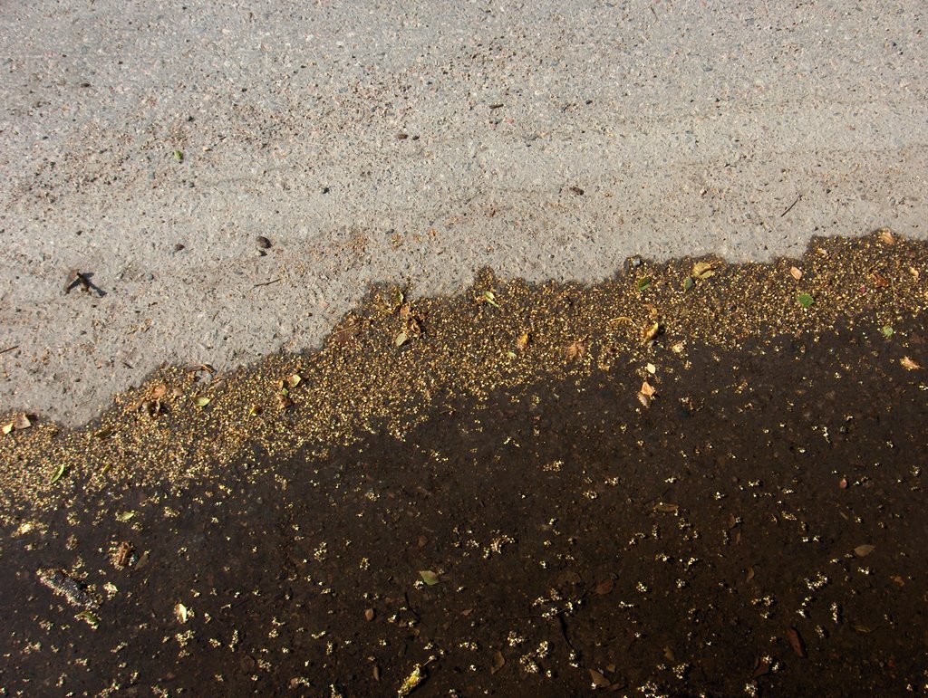
Yllä on kuuden kuvan sarja, joka näyttää yhtäältä 22. päivänä olleen sateen ilmentymiä ja toisaalta edelleen pahentuneen kuivuuden ilmentymiä. Kuivuus oli kehittymässä tässä vaiheessa pienestä sateesta huolimatta etelärannikolla etenkin sen länsiosissa jo tunnetun historian toiseksi pahimmaksi. Vain kesällä 1955 oli ollut kuivempaa tässä vaiheessa. Kaikki nämä kuvat on kuvattu Espoon Tapiolassa, jolloin kesän kuudes helleaalto oli alkanut; päivän ylin lämpötila oli +25,8 astetta. Tässä tilanteessa pohjoisesta oli lähestymässä hitaasti kylmä rintama ja siihen liittyen ukkospilvialue oli pohjoisella taivaanrannalla, mutta vielä melko kaukana. Tässä kuvassa nähdään toissa päiväsestä sateesta jäänyttä vesilätäkköä asfaltilla. Tässäkin oli koivujen siemeniä, kuten edellisessä kuvaparissa. Tämän lätäkön kuivumista hidasti se, että se sijaitsi melko varjoisassa kohdassa kerrostalon pohjoispuolella. Lätäkön kuivumisesta jäi asfalttiin raitoja veden likaisuuden takia. Raidat näyttivät kuivumisen eri vaiheita tähän mennessä; erilaiset vyöhykkeet johtuivat siitä, kun kuivuminen oli erilaista yöllä verrattuna päivään. Nuo koivun siemenet laskeutuivat ko. pinnalle vasta ko. päivänä, sillä ne olivat asettuneet tasaisesti uloimman märän alueen pinnalle. Säätilanne: valitse Base Time 24.7.2006. Wetter3 A. Wetter3 B.
Above there is a series of six pictures, which shows in one hand appearances of the rain in the 22nd day and on the other hand appearances of the further worsened drought. Despite the little rain the drought was being progressed at this stage by the southern coast especially in the western parts of it into the second worst drought of the known history (in Finland). At this phase only the summer of 1955 had been drier. All these pictures are photographed in the district of Tapiola in Espoo at the time, when the sixth heatwave of the summer had been started; the maximum temperature of the day was +25,8 C. At this situation there was a cold front approaching slowly from the north and as associated with that there was a thundercloud / cumulonimbus cloud area in the northern horizon, but yet rather far away. In this picture we see a puddle of water on an asphalt remained from the rain of the 22nd day. In here there was also seeds of Birches as in the previous pair of photos too. The drying of this puddle was slowed down due to the fact, that it was in a rather shadowy spot in the northern side of a highrise building. There remained stripes on the asphalt from the drying process of the puddle. The stripes were showing different phases of the drying up to this point; different types of zones were resulted by the fact, where the drying was a different kind at night as compared to the daytime. Those seeds of Birches fell on that surface only during this day, because they were settled evenly onto that outermost wet zone. Weather condition: choose Base Time 24.7.2006. Wetter3 A. Wetter3 B.
Helsingin Puistolan säätilasto heinäkuussa 2006 - Weather chart of Puistola, Helsinki in July 2006.
Flickr 1 Flickr 2
Tehoisa lämpösumma - The Effective Temperature Sum: 878,3
posted by Mika at 4:45 PM
![]()


0 Comments:
Post a Comment
<< Home