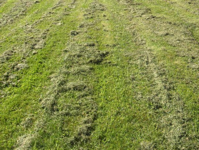
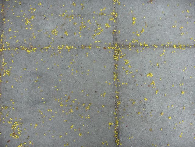
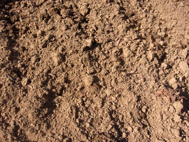
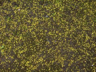
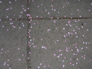
Joitakin nurmikoita oli leikattu tässä vaiheessa jo kahteen kertaan, vaikka pitkään jatkunut viileä sää oli jarruttanut kasvukauden kehitystä. Tämä nurmikko oli yksi niistä ja se oli leikattu vain parisen tuntia ennen tämän kuvan ottoa. Leikkaamisesta jäi jäljelle korsijätettä, joka muodosti nuo raidat. Tällainen vastaleikattu nurmikko tuottaa tyypillisen voimakkaan tuoksun, joka tuntui myös tässä tilanteessa. Se toi tilanteessa vallinneeseen viileään säähän jo kesän tuntua. Edellisen kuvasarjan jälkeen ylin lämpötila oli 25. päivänä vain +15,1 astetta ja ko. päivänä +14,9 astetta. Yölämpötilat olivat 24. päivän jälkeen enimmäkseen +1 ja +5 asteen välillä ja hallaa oli muutamana yönä paikoin. Tällaisilla nurmikoilla halla aiheutti runsaasti valkoista kuuraa. Pitkien päivien vuoksi sen esiintyminen oli kuitenkin vain muutaman tunnin mittaista öiden pikkutunneilla; aurinko nousi näinä aikoina vähän aamuneljän jälkeen ja se sulatti paikallisen kuuran ennen ihmisten heräämistä. Monet matalapaineet olivat tuoneen myös ajoittain sadekuuroja ja kuurottaista sadetta, mutta tänä päivänä etelärannikolla oli pääasiassa poutaa ja osaksi aurinkoista. Sateiden, viileän sään ja valoisten päivien vuoksi nurmikot olivat nyt voimakkaan vihreitä. Säätilanne: valitse Base Time 30.5.2006. Wetter3 A. Wetter3 B.
Some lawns had been mowed at this stage allready twice, allthough a longlasting cool weather had been slowed down the progress of the growing season. This lawn was one of them and it had been mowed only couple of hours earlier of the shooting of this photo. From the mowing there was left straw trash, which formed those stripes. This kind of just mowed lawn produces typical strong smell, which was felt also in this case. It brought allready summery feel into the prevailed cool weather in the situation. After the previous photo series the maximum temperature was only +15,1 C at the 25th day and in this day +14,9 C. The night temperatures were since the 24th day mainly between +1 C and +5 C and there was ground frost during a few nights locally. On these kinds of lawns ground frost caused a lot of white frost. However due to the long days the appearing of it was only couple of hours long during the small hours of the nights; the sun rose at these times a little after 4 am and it melt the local frost before people woke up. Many low pressures had been brought occasional showers and showery rain as well during many days, but today by the southern coast it was mainly dry and partly sunny. Due to the rains, the cool weather and the light filled days the lawns were now strongly green. Weather condition: choose Base Time 30.5.2006. Wetter3 A. Wetter3 B.
Helsingin Puistolan säätilasto toukokuussa 2006 - Weather chart of Puistola, Helsinki in May 2006.Flickr 1 Flickr 2
Tehoisa lämpösumma - The Effective Temperature Sum: 187,3 

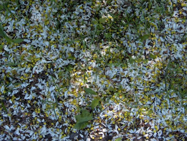
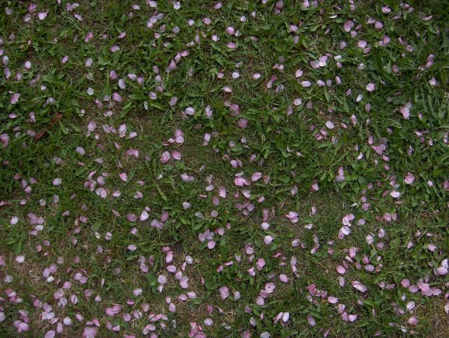
Voimakas tuuli oli varistanut tässä runsaasti myös sirotuomipihlajan kukkien terälehtiä metsävaahteran kokonaisten kukkien sekaan nurmikolle. Terälehtien valkoinen väri oli taipunut vähän siniseen suuntaan, koska paikan yläpuolella oli laajasti sinistä taivasta vähäisen pilvisyyden vuoksi. Vaaleat kohdat olivat puiden lehvästön läpi pilkottanutta auringonvaloa. Tämä kuva päättää tämän neljän kuvan sarjan. Säätilanne: valitse Base Time 24.5.2006. Wetter3 A. Wetter3 B.
In here the strong wind had been shed plenty of Allegheny Serviceberry's flower petals among Norway Maple's whole flowers on a lawn. The white colour of the petals had been transformed a little towards blue direction, because there was widely blue sky over the spot due to a minor amount of cloudyness. The light spots were sunlight peeped through the leaves of the trees. This picture ends this photo series of four pictures. Weather condition: choose Base Time 24.5.2006. Wetter3 A. Wetter3 B.
Helsingin Puistolan säätilasto toukokuussa 2006 - Weather chart of Puistola, Helsinki in May 2006.Flickr 1 Flickr 2
Tehoisa lämpösumma - The Effective Temperature Sum: 162,5
Tässä metsävaahteran varisseita kukkia oli muualla asfaltilla. Mukana tässä oli myös hieman varisseita valkoisia sirotuomipihlajan (Amelanchier laevis) kukkien terälehtiä. Asfaltti oli tässä kuivempaa kuin edellisessä kuvassa, mutta kova tuuli ei liikuttanut märkiä kukkia. Tuuli oli kuitenkin niin voimakasta, että tässä nähdään jopa yksittäisiä puista riipiytyneitä kukkaterttuja. Säätilanne: valitse Base Time 24.5.2006. Wetter3 A. Wetter3 B.
In here there were shed flowers of Norway Maple elsewhere on the asphalt. Among here there were also a little of shed white flower petals of Allegheny Serviceberry (Amelanchier laevis). The asphalt was here drier than in the previous picture, but hard wind didn't move these wet flowers. However the wind was so strong, that in here we see even single flower recemes stripped away from the trees. Weather condition: choose Base Time 24.5.2006. Wetter3 A. Wetter3 B.
Helsingin Puistolan säätilasto toukokuussa 2006 - Weather chart of Puistola, Helsinki in May 2006.Flickr 1 Flickr 2
Tehoisa lämpösumma - The Effective Temperature Sum: 162,5

Jo edellisessä kuvasarjassa oli nähtävissä runsaasti varisseita metsävaahteran (Acer platanoides) kukkia, mutta tämän päivän kova tuuli oli varistanut niitä vielä lisää. Tässä kuvassa ko. kukkia oli vielä märän asfaltin päällä auringon paistettua puiden lehvästön läpi. Asfaltin märkyys säilyi tässä pidempään kuin muulla osalla ko. pintaa näiden kukkien takia. Säätilanne: valitse Base Time 24.5.2006. Wetter3 A. Wetter3 B.
Allready in the previous photo series there was visible a lot of shed flowers of Norway Maple (Acer platanoides), but the strong wind of this day had been shed them yet more. In this picture those flowers were on the yet wet asphalt as the sun shined through the leaves of the trees. The wetness of the asphalt remained here longer than in other parts of the surface due to these flowers. Weather condition: choose Base Time 24.5.2006. Wetter3 A. Wetter3 B.
Helsingin Puistolan säätilasto toukokuussa 2006 - Weather chart of Puistola, Helsinki in May 2006.Flickr 1 Flickr 2
Tehoisa lämpösumma - The Effective Temperature Sum: 162,5
Yllä oleva 4 kuvan sarja on kuvattu samana iltapäivänä Espoon Tapiolassa. Kuvat on laitettu järjestykseen taiteellisten seikkojen mukaan. Ilmoitettu aikaskaala pitää kuitenkin paikkansa. Melko voimakas matalapaine oli tässä vaiheessa eteläisen Suomen yllä. Sen myötä länsituuli oli kuvauspäivänä voimakasta. Edellisenä yönä ja aamulla oli sadekuuroja, mutta iltapäivän aikana oli ajoittain vähän pilviä. Sen ansiosta näissä kuvissa nähdään runsaasti auringonvaloa. Voimakas tuuli aiheutti kukintansa päättävistä puista ja pensaista runsaasti laskeumaa, joista tässä lisää esimerkkejä. Tässä kuvassa rauduskoivun (Betula pendula) hedenorkkoja oli varissut runsaasti asfaltille ja voimakas tuuli oli jopa riipinyt muutaman tuoreen lehdenkin puista. Norkot eivät liikkuneet tuulen mukana pitkin ko. pintaa, koska päivän aikaisempien sateiden vuoksi ne olivat märkinä kuin liimautuneita alustaansa. Säätilanne: valitse Base Time 24.5.2006. Wetter3 A. Wetter3 B.
The 4 picture series above is captured during the same afternoon in the district of Tapiola in Espoo. The photos are placed in order according to artistic matters. However the mentioned time scale holds true. Rather strong low pressure was at this stage over Finland. Due to that westerly winds were strong during the day. During the last night and in the morning there were showers, but during the afternoon there were occasionally minor amount of clouds. Due to that we see in the pictures plenty of sunlight. The strong wind caused fallout from the trees and shrubs ending their blooming and here are some examples of that. In this picture male catkins of Silver Birch (Betula pendula) had been shed a lot on the asphalt and the strong wind had even stripped away a few fresh leaves from the trees. The catkins weren't moving across this surface with the wind, because due to the earlier rain of this day they were like glued onto the platform as they were wet. Weather condition: choose Base Time 24.5.2006. Wetter3 A. Wetter3 B.
Helsingin Puistolan säätilasto toukokuussa 2006 - Weather chart of Puistola, Helsinki in May 2006.Flickr 1 Flickr 2
Tehoisa lämpösumma - The Effective Temperature Sum: 162,5
 Tämän Espoon Tapiolassa otetun kuvasarjan päättää tämä rauduskoivun (Betula pendula) hedenorkkoja esittelevä kuva. Kuten alempana sarjassa, niin myös tässä oli melko runsaasti tämän lajin varisseita norkkoja laajalla alueella; suuria koivuja on paikalla paljon. Tässä vaiheessa aurinko pilkahti sen verran pilvien takaa, että se loi kellertävää illan sävyä tilanteeseen. Märkä asfaltti muodosti myös hauskan kontrastin norkoille. Keltaisimmat norkot olivat tippuneet viimeisimpänä tänä päivänä ja tummimmat jo muutamia päiviä sitten. Säätilanne: valitse Base Time 23.5.2006. Wetter3 A. Wetter3 B.This picture showing male catkins of Silver Birch (Betula pendula) ends this photo series as pictured in the district of Tapiola in Espoo. As in the lower parts of the series, in here there was also rather profusely shed catkins of this species on a wide area; there are big birches in the place. At this stage the sun peeped out in such a way, that it created an yellowish evening tone into this situation. The wet asphalt formed also a funny contrast to the catkins. The most yellow catkins had been dropped the latest in this day and the darkest catkins allready a couple of days ago. Weather condition: choose Base Time 23.5.2006. Wetter3 A. Wetter3 B.Helsingin Puistolan säätilasto toukokuussa 2006 - Weather chart of Puistola, Helsinki in May 2006.Flickr 1 Flickr 2Tehoisa lämpösumma - The Effective Temperature Sum: 158,8
 Tässä metsävaahteran kukkia oli varissut sammaloituneen nurmikon kohdalle. Kohta oli sen verran tuulensuojainen ja sadevesi imeytyi sen verran hyvin maahan, että nuo kukat jäivät tasaisesti ko. pinnalle. Maan karkea pinta auttoi myös asiaa. Tämä ja kaksi alempaa kuvaa on kuvattu samalla paikalla, jossa metsävaahteroita on monta isoa puuta. Siten varisseitten kukkien määrä oli runsas. Säätilanne: valitse Base Time 23.5.2006. Wetter3 A. Wetter3 B.In here the flowers of Norway Maple had been shed on a mossy spot of lawn. The spot was wind protected in such a way and the rain water absorbed so well into the ground, that those flowers remained evenly on that surface. The coarse surface of the ground helped also the case. This and lower two pictures are taken in the same place, where there are many big trees of Norway Maple. Therefore the amount of shed flowers was big. Weather condition: choose Base Time 23.5.2006. Wetter3 A. Wetter3 B.Helsingin Puistolan säätilasto toukokuussa 2006 - Weather chart of Puistola, Helsinki in May 2006.Flickr 1 Flickr 2Tehoisa lämpösumma - The Effective Temperature Sum: 158,8
 Jo edellisessä kuvasarjassa oli esimerkki metsävaahteran (Acer platanoides) kukkien varisemisesta, mutta tässä vaiheessa sateen ja tuulten ansiosta kukkia oli varissut yhä enemmän; puut olivat jo melkein tyhjiä kukista ja ainakin suurimmaksi osaksi tuore lehdistö oli nyt enemmän esillä ko. puissa kuin jäljellä olevat kukat. Sadeveden mukana tämäkin laskeuma muodosti hienoja kuvioita, kuten tässä asfaltoidun käytävän reunassa sadevesikourussa. Säätilanne: valitse Base Time 23.5.2006. Wetter3 A. Wetter3 B.Allready in the previous photo series there was an example on shed flowers of Norway Maple (Acer platanoides), but at this stage further more flowers had been shed due to the rain and winds; the trees were allready allmost empty of flowers and at least for the most part fresh leaves were now more exposed in these trees than the remaining flowers. With the rain water also this fallout formed fine shapes, as on the rain water channel of the asphalted path's edge in here. Weather condition: choose Base Time 23.5.2006. Wetter3 A. Wetter3 B.Helsingin Puistolan säätilasto toukokuussa 2006 - Weather chart of Puistola, Helsinki in May 2006.Flickr 1 Flickr 2Tehoisa lämpösumma - The Effective Temperature Sum: 158,8
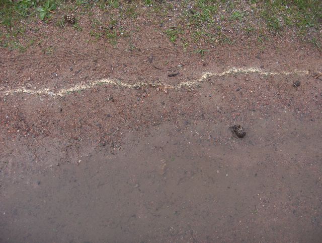
 Tilanne oli tässä muutoin sama kuin edellisessä kuvassa, mutta tässä on näkyvissä myös sitä ko. käytävää, jolla hiekka oli valunut sadeveden mukana. Kuvan norkotkin olivat kasautuneet veden takia. Noihin koivun norkkoihin liittyen mainitsen, että alimmassa kuvassa ollut siitepöly oli peräisin etenkin juuri koivuista, sillä toukokuun alkupuolella niiden siitepölyä oli ollut ilmassa tyypillisesti eniten. Säätilanne: valitse Base Time 23.5.2006. Wetter3 A. Wetter3 B.The situation was here otherwise the same as in the previous picture, but in here there was visible also that sandy path, in which the sand was flowed by the rain water. The catkins in the picture had also been piled up due to the water. Related to those birch catkins i mention, that pollen in the lowest picture came especially just from birches, because during the early part of May pollen of them had been in the air typically the most. Weather condition: choose Base Time 23.5.2006. Wetter3 A. Wetter3 B.Helsingin Puistolan säätilasto toukokuussa 2006 - Weather chart of Puistola, Helsinki in May 2006.Flickr 1 Flickr 2Tehoisa lämpösumma - The Effective Temperature Sum: 158,8
 Sade oli sen verran rankkaa aikaisemmin iltapäivällä, että hiekkapintaisilla väylillä hiekkaa valui helposti sadeveden mukana. Tässä kuvassa sitä oli valunut käytävän viereiselle mullokselle. Kuvassa nähdään myös varisseita rauduskoivun (Betula pendula) hedenorkkoja. Sen kukinta oli siten päättymässä ja sekä sateen että tuulten ansiosta näitä norkkoja oli jo ilmestynyt maahan. Kohdan yllä on isoja koivuja. Säätilanne: valitse Base Time 23.5.2006. Wetter3 A. Wetter3 B.The rain was heavy in such a way earlier during the afternoon, that on the sand paved paths sand was flowed easily by the rain water. In here it had been flowed into the dirt covered ground beside the path. We see in the picture also shed male catkins of Silver Birch (Betula pendula). The blooming of it was therefore ending and due to both the rain and the winds these catkins had allready been appeared on the ground. There are big birches over the spot. Weather condition: choose Base Time 23.5.2006. Wetter3 A. Wetter3 B.Helsingin Puistolan säätilasto toukokuussa 2006 - Weather chart of Puistola, Helsinki in May 2006.Flickr 1 Flickr 2Tehoisa lämpösumma - The Effective Temperature Sum: 158,8
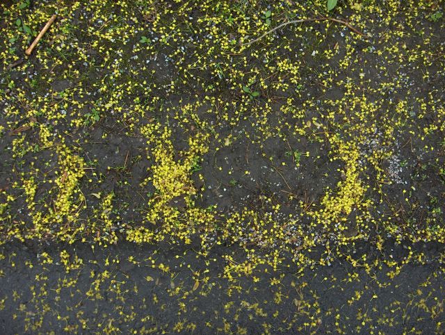
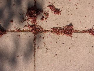
 Yllä oleva 7 kuvan sarja on kuvattu samana iltana Espoon Tapiolassa. Kuvat on laitettu järjestykseen taiteellisten seikkojen mukaan, mutta ko. aikaskaala pitää paikkansa. Kuvien ottamisen aikana melko runsas sadealue (sademäärä oli ko. päivänä 13,6mm) oli juuri ylittänyt ko. alueen ja ennen seuraavan yön kuurosateita sää oli hetken aikaa poutaista, mutta pilvistä. Sade liittyi okluusiorintamaan, joka saapui lännestä voimistuvan matalapaineen myötä. Seuraavana yönä länsituuli voimistui huomattavasti, mutta jo kuvauspäivänä oli ajoittain vähintään kohtalaisia tuulia. Sade ja tuulet aiheuttivat maan pinnalle monenlaisia jälkiä ja jätöksiä, joista tässä on esimerkkejä. Alimmissa kolmessa kuvassa on sateen aiheuttamia jälkiä, joista tässä kuvassa nähdään siitepölystä muodostunut keltainen viiru hiekkakäytävällä. Siitepöly muodostaa helposti sadeveden kanssa tällaisia kuvioita. Siitepöly paljasti näin tuon lätäkön laajimman vaiheen, koska siitepöly kerääntyy helposti lätäköiden reunoille veden pintajännityksen avulla. Säätilanne: valitse Base Time 23.5.2006. Wetter3 A. Wetter3 B.The 7 picture series above is photographed in the district of Tapiola in Espoo during the same evening. The photos are placed in order according to artistic matters, but the timescale in question holds true. During the shooting of the pictures a rather heavy precipitation area (the amount of precipitation was 13,6 millimetres) had just been crossed the scene and before the next night's showers it was temporarily dry, but cloudy. The rain was associated with an occluded front, which came from the west along a strengthening low pressure. During the next night winds got signifigantly stronger, but allready during the photoshooting day there was at least occasionally moderate winds. The rain and winds caused many kinds of tracks and leavings on the ground and some of them are presented here as examples. In the lowest three pictures there are tracks leaved by the rain and in this picture we see in the sandy path an yellow stripe formed of pollen. Pollen forms easily these kinds of shapes with the rain water. Pollen revealed in this way the largest phase of that puddle, because pollen gathers easily on the edges of puddles helped by the waters surface tension. Weather condition: choose Base Time 23.5.2006. Wetter3 A. Wetter3 B.Helsingin Puistolan säätilasto toukokuussa 2006 - Weather chart of Puistola, Helsinki in May 2006.Flickr 1 Flickr 2Tehoisa lämpösumma - The Effective Temperature Sum: 158,8
 Edellisen kuvasarjan jälkeen pohjoisella Atlantilla ja Britteinsaarilla ollut laaja matalapaine useine keskuksineen oli 19. - 21. päivinä lähempänä Suomea. Sen myötä useita matalan osakeskuksia liikkui Suomen ympärillä ja Suomen ylikin tuoden ajoittain lähinnä kuurottaista sadetta. Ilmamassa pysyi kuitenkin edelleen viileanä ja päivälämpötilat olivat vain +10 asteen tienoilla. Runsaan pilvisyyden ja ajoittaisten sateiden ansiosta hallaa ei enää ollut 19. päivästä lähtien. Ko. kuvan ottamisen tienoilla vallitsi tilapäisesti korkeapaineen selänne ja sen myötä varsin aurinkoinen ja lämmin sää; ylin lämpötila oli +20,0 astetta. Tämä kuva on otettu samalla Espoon Tapiolan paikalla kuin edellisen kuvasarjan rusokirsikoiden (Prunus sargentii) kukkien terälehtikuvat. Tässä nähdään ko. puulajin varisseita kukkaperiä ja ruskeiksi kuivuneita terälehtiä, joita tuuli oli kasannut. Tämä puu varistaa terälehtien jälkeen n. viikon päästä kokonaan ne kukat, joista ei synny hedelmiä. Suomen oloissa näin käy yleensä helposti, mutta tiedän tämän puuryhmän tuottavan kypsiä marjoja runsaasti joka kesä (keskimäärin kesäkuun viimeisellä viikolla). Säätilanne: valitse Base Time 22.5.2006. Wetter3 A. Wetter3 B.After the previous photo series a large low pressure situated in northern Atlantic and British Isles with many centers was during the 19th to the 21st days nearer Finland. Due to that several low pressure subcenters moved around Finland and also across Finland bringing occasionally mainly showery rain. However the air mass stayed further cool and the afternoon temperatures were only around +10 C. Due to the plentyfull cloudyness and the occasional rain there wasn't ground frost anymore from the 19th day onwards. Around the shooting of this photo there prevailed a ridge of high pressure temporarily, which brought rather sunny and warm weather; the maximum temperature was +20,0 C. This picture is taken in the same spot in the district of Tapiola in Espoo as the Sargent Cherry's (Prunus sargentii) flower petal photos in the previous photo series. In here we see shed pedicels and into brown dried up petals of this tree species. The wind had been piled them up. This tree sheds after the petals about one week later those flowers as a whole, which doesn't form into fruits. In the circumstances of Finland this happens usually easily, but i know this group of trees to be able to form plenty of ripe berries every summer (on an average during the last week of June). Weather condition: choose Base Time 22.5.2006. Wetter3 A. Wetter3 B.Helsingin Puistolan säätilasto toukokuussa 2006 - Weather chart of Puistola, Helsinki in May 2006.Flickr 1 Flickr 2Tehoisa lämpösumma - The Effective Temperature Sum: 153
 Nämä karvaiset "turrit" ovat raidan hedenorkkoja; keltaiset heteet olivat kuivuneet jo niin paljon, että harmaakarvainen norkkovarsi oli uudestaan esillä. Raidan kukinta-aika on vähän ennen noiden kahden alempana esitellyn puulajin kukintaa. Sen vuoksi nämä norkot olivat varisseet jo em. lajien kukinnan alussa n. viikko sitten. Koska raita on kaksikotinen puulaji, niin tässä vaiheessa emiyksilöissä eminorkot olivat kehittymässä hedelmänorkoiksi. Niiden variseminen tapahtuu Etelä-Suomessa yleensä touko-kesäkuun vaihteessa, kun ko. norkot ovat päästäneet ilmaan valkohaivenelliset siemenensä. Tämä kuva päättää kuuden kuuden kuvan sarjan; kuvat on laitettu taiteellisten seikkojen mukaan järjestykseen, mutta kuvauksen aikaskaala pitää paikkansa. Kuvaustilanteessa kasvukausi oli vielä n. viikon edellä tavanomaisesta, vaikka hyvin kylmä sää jarrutti kehitystä tässä vaiheessa. Säätilanne: valitse Base Time 16.5.2006. Wetter3 A. Wetter3 B.These shaggy "dogs" are male catkins of Goat Willow; the yellow stamens had been dried up allready so much, that grey hairs of the catkin's stem were exposed again. The blooming time of Goat Willow is a little earlier than the blooming time of those two tree species shown lower. Therefore these catkins had been shed allready at the start of the blooming of those mentioned species about a week ago. Because Goat Willow is dioicous plant, therefore the female catkins were at this stage in the tree forming into fruiting catkins. Shedding of them happens in southern Finland usually at the turn of may and june, as these catkins have released the white downy seeds into the air. This picture ends the six picture series; the photos are placed in order according to artistic matters, but the time scale of the photoshooting holds true. During the photoshooting moment the growing season was yet about one week ahead of the average, allthough very cold weather slowed down the progress at this stage. Weather condition: choose Base Time 16.5.2006. Wetter3 A. Wetter3 B.Helsingin Puistolan säätilasto toukokuussa 2006 - Weather chart of Puistola, Helsinki in May 2006.Flickr 1 Flickr 2Tehoisa lämpösumma - The Effective Temperature Sum: 127,5
 Kuvan varisseet metsävaahteran kukat olivat tyypillisesti tippuneet kokonaisina. Tällä puulajilla on sama kukinta-aika kuin rusokirsikalla ja sen vuoksi tätä laskeumaa nähdään samana aikana edellisten kuvien laskeuman kanssa. Tämä laskeuma tosin kestää pidemmän ajan. Metsävaahteran kukista varisee hyvin vähän yksittäisiä terälehtiä näkyvällä tavalla, koska hedelmiksi kehittyvissä kukissa terälehdet kuivuvat ennen varisemistaan. Sen sijaan ne kukat, joista ei kehity hedelmiä varisevat kokonaisina runsain massoin tuoreen keltaisina heti kukinnan lopulla. Tässä siitä yksi esimerkki; eri tilanteiden kuvia tämän lajin kukkalaskeumasta ilmestyy vielä lisää. Säätilanne: valitse Base Time 16.5.2006. Wetter3 A. Wetter3 B.In the photo the flowers of Norway Maple had typically been dropped as a whole. This tree species has the same blooming time as Sargent Cherry and therefore this fallout is seen at the same time as the fallout of the previous pictures. This fallout lasts loger time though. Very little single flower petals are shed from Norway Maple in a visible way, because the petals in the flowers turning into fruits are drying up before they fall. As on the other had those flowers, which doesn't turn into fruits are shed as a whole in plentyfull freshly yellow masses right at the end of the blooming. In here there is one example of that; pictures of the flower fallout of this species in different situations will appear yet more. Weather condition: choose Base Time 16.5.2006. Wetter3 A. Wetter3 B.Helsingin Puistolan säätilasto toukokuussa 2006 - Weather chart of Puistola, Helsinki in May 2006.Flickr 1 Flickr 2Tehoisa lämpösumma - The Effective Temperature Sum: 127,5
 Alempaan kuvaan verrattuna aurinko paistoi tässä puiden lehvästön läpi samalle nurmikon kohdalle. Ko. puiden varjot olivat itse asiassa juuri niiden rusokirsikoiden varjoja, jotka varistivat nämä terälehdet. Puut olivat jo melkein tyhjiä terälehdistä ja lähinnä kevätväriset lehdet olivat jäljellä. Kasvukausi oli tämän puulajin kohdalla edennyt epätasaisesti kasvupaikasta riippuen; lämpimimmillä paikoilla kukinta ehti päättyä ennen tässä vaiheessa vallinnutta kylmää jaksoa, mutta viileimmillä paikoilla pääkaupungin ympäristössä kukinta jatkui vielä tässäkin vaiheessa. Joka tapauksessa nämä neljä kuvaa näyttävät varisseiden terälehtien kauneusarvon. Kirsikoilla se on jo entuudestaan tunnettu fakta, mutta muidenkin lajien kohdalla tällaista laskeumaa ei kannata pitää roskana. Säätilanne: valitse Base Time 16.5.2006. Wetter3 A. Wetter3 B.As compared to the lower picture the sun shined here through the trees on the same spot of lawn. The shadows in question are actually just the shadows of those Sargent Cherrys, which shed these petals. The trees were allmost empty of the petals and mainly spring coloured leaves remained. The growing season had been progressed unevenly in the case of this tree species according to the growing place; on the warmest places the blooming had time to end before the cold spell of weather which prevailed at this moment, but on the coolest places around the Helsinki area the blooming continued yet also at this stage. In any case these four pictures show the beauty value of the shattered petals. With cherrys that's allready known fact, but also in cases of other species this kind of fallout isn't worth to consider as a rubbish. Weather condition: choose Base Time 16.5.2006. Wetter3 A. Wetter3 B.Helsingin Puistolan säätilasto toukokuussa 2006 - Weather chart of Puistola, Helsinki in May 2006.Flickr 1 Flickr 2Tehoisa lämpösumma - The Effective Temperature Sum: 127,5
 Ylempään kuvaan verrattuna nämä terälehdet oli kuvattu auringon oltua pilvessä. Ko. päivänä vallitsevat pilvilajit olivat kumpu- ja kumpukerrospilvet. Näissä kahdessa kuvassa rusokirsikan kukkien terälehtien lisäksi nähdään nurmikolla olleita voikukan (Taraxacum officinale) lehtiä. Tällä kohdalla niiden kukinta ei ollut vielä alkanut, mutta monella muulla lämpimämmällä paikalla kukintaa oli jo keltaisenaan. Tätä nurmikkoa ei oltu vielä leikattu tänä vuonna. Säätilanne: valitse Base Time 16.5.2006. Wetter3 A. Wetter3 B.As compared to the upper photo these petals were pictured, when the sun was behind the clouds. During this day the prevailing cloud types were cumulus and stratocumulus clouds. In these two pictures besides the flower petals of Sargent Cherry we see leaves of Dandelions (Taraxacum officinale) on the lawn. On this spot their blooming hadn't yet been started, but on many warmer places there were allready blooming in a full yellow fashion. This lawn hadn't yet been cut in this year. Weather condition: choose Base Time 16.5.2006. Wetter3 A. Wetter3 B.Helsingin Puistolan säätilasto toukokuussa 2006 - Weather chart of Puistola, Helsinki in May 2006.Flickr 1 Flickr 2Tehoisa lämpösumma - The Effective Temperature Sum: 127,5
 Edellisessä kuvassa rusokirsikan kukkien terälehdet olivat kevyen liikenteen väylän laattakiveyksellä. Tässä ne olivat pensasryhmän viereisellä hiekkalaikulla. Tässä kuvassa nähdään hyvin, kuinka tuuli oli sijoittellut terälehtiä kuoppakohtiin. Kaikki nämä neljä terälehtikuvaa on kuvattu saman Tapiolan keskustassa olevan rusokirsikkaryhmän vieressä. Säätilanne: valitse Base Time 16.5.2006. Wetter3 A. Wetter3 B.In the previous picture the flower petals of Sargent Cherry were on the flag stone pavement of the pedestrian path. In here they were on the sandy patch beside a group of shrubs. In this picture we see finely, how the wind had been settled these petals on bumpy spots. All these petal pictures are photographed near the same group of Sargent Cherrys in the center of Tapiola. Weather condition: choose Base Time 16.5.2006. Wetter3 A. Wetter3 B.Helsingin Puistolan säätilasto toukokuussa 2006 - Weather chart of Puistola, Helsinki in May 2006.Flickr 1 Flickr 2Tehoisa lämpösumma - The Effective Temperature Sum: 127,5
 Yllä on kuuden kuvan sarja kuvattuna samana päivänä. Ylin kuva on kuvattu Espoon Otaniemessä ja kaikki muut Espoon Tapiolassa. Alemmissa neljässä kuvassa nähdään rusokirsikan (Prunus sargentii) kukkien varisseita terälehtiä. Toiseksi ylimmässä kuvassa on metsävaahteran (Acer platanoides) varisseita kukkia ja ylimmässä kuvassa raidan (Salix caprea) varisseita hedenorkkoja. Näiden kuvien ottamisen ajaksi poikkeuksellisen lämmin sää oli vaihtunut hyvin kylmäksi sääksi kuun 13. päivän tienoilla. Edellisen kuvasarjan jälkeen 9. päivänä vuorokauden ylin lämpötila oli vielä +22,5 astetta, mutta tätä edeltävänä päivänä enää +9,6 astetta. Hallaa oli jo edellisenä yönä etenkin sisämaassa, mutta sään seljettyä seuraavaksi yöksi myös etelärannikolla oli ankaran hallan lisäksi yöpakkastakin 2 metrin korkeudella; lukema oli´-2,4 astetta. Kylmän sään aiheutti Suomen länsipuolelta voimistuneena koilliseen liikkunut matalapaine, joka 13. päivän jälkeen kierrätti ilmaa koko Suomeen luoteis- ja pohjoistuulten mukana aina pohjoisnavalta saakka. Säätilanne: valitse Base Time 16.5.2006. Wetter3 A. Wetter3 B.Above there is a six picture series photographed in the same day. The highest picture is taken in the district of Otaniemi in Espoo and everyone else in the district of Tapiola in Espoo. In the lower four pictures we see shed flower petals of Sargent Cherry (Prunus sargentii). In the second highest picture there was shed flowers of Norway Maple (Acer platanoides) and in the highest photo shed male catkins of Goat Willow (Salix caprea). Until the shooting time of these photos the unusually warm weather had been turned into a very cold weather at around the 13th day of the month. After the previous photo series at the 9th day the day's maximum temperature was yet +22,5 C, but at the previous day before this day it was only +9,6 C. There was allready ground frost at the last night especially in inland areas, but as the weather got clear for the next night there was also by the southern coast frost in the height of 2 metres (the reading was -2,4 C) in addition to a severe ground frost. The cold weather was resulted by a low pressure, which moved in a strengthened fashion to the northeast from the western side of Finland. The low pressure circulated air all the way from the northpole into whole Finland with northwesterly and northerly winds from the 13th day onwards. Weather condition: choose Base Time 16.5.2006. Wetter3 A. Wetter3 B.Helsingin Puistolan säätilasto toukokuussa 2006 - Weather chart of Puistola, Helsinki in May 2006.Flickr 1 Flickr 2
Tehoisa lämpösumma - The Effective Temperature Sum: 127,5

Tämä kuva päättää tämän kolmen kuvan sarjan kuvattuna samana päivänä Espoon Tapiolassa. Kuvassa on nurmikkoa, jossa voikukat (Taraxacum officinale) olivat alkaneet paikoin kukkia. Toukokuun lämpöaalto oli vaikuttanut myös nurmikoiden kasvuun niin, että joitakin niistä leikattiin näinä aikoina ensimmäisen kerran tänä vuonna. Tämä nurmikko ei kuitenkaan ollut vielä yksi niistä. Suomalaisilla nurmikoilla voikukat ovat usein hyvin yleisiä. Niitä pidetään yleensä rikkaruohoina, mutta minun näkemyksen mukaan ne ovat ehdottoman kauniita loppukevään ja alkukesän maisemakasveja, joita pitää suosia. Säätilanne: valitse Base Time 8.5.2006. Wetter3 A. Wetter3 B.
This picture ends this three picture series as photographed in the same day in the district of Tapiola in Espoo. In the picture there's a lawn, where Dandelions (Taraxacum officinale) had been started to blossom locally. The wave of warm air during may had been affected also to the growth of the lawns in a way, that around this time some of them were being mowed for the first time this year. However this lawn wasn't one of them. On the finnish lawns dandelions are many times very common. They are considered usually as weeds, but according to my vision they are dead beautiful late spring and early summer landscape plants, which must be favoured. Weather condition: choose Base Time 8.5.2006. Wetter3 A. Wetter3 B.
Helsingin Puistolan säätilasto toukokuussa 2006 - Weather chart of Puistola, Helsinki in May 2006.Flickr 1 Flickr 2
Tehoisa lämpösumma - The Effective Temperature Sum: 86,6

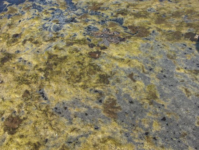
Tässä kuvassa oli vähemmän edellisen syksyn metsävaahteran (Acer platanoides) lehtiä lumen ja jään sulamisprosessissa syntyneen vaahdon mukana ko. lätäkössä. Tässäkin kuvassa nähdään, kuinka edellisinä päivinä vaikuttanut hyvin lämmin sää oli edistänyt levien kasvua tällä pinnalla. Levien lisäksi kellertävyyttä tässä vedessä lisäsi ilman suuri siitepölypitoisuus (laskeuma), koska kasvukauden edettyä nopeasti mm. koivut (Betula sp.) kukkivat nopeasti kerralla ja ne syytivät ilmaan kuivan sään aikana hyvin paljon siitepölyä. Myös kuvan lätäkön viereisten hiekkakäytävien pölyä laskeutui tälle pinnalle jonkin verran toukokuun alun aikana. Säätilanne: valitse Base Time 8.5.2006. Wetter3 A. Wetter3 B.
In this picture there was less Norway Maple (Acer platanoides) leaves of the previous autumn among the foam formed from the snow's and ice's melting process on this puddle. Also in this photo we see, how the affected very warm weather during previous days had been fowarded the growth of algae on this surface. Besides the algae yellowish colour was increased in this water by the big amount of pollen in the air (the fallout), because as the growing season progressed rapidly for example birches (Betula sp.) were blooming rapidly at once and they emitted very much pollen into the air during the dry weather. Also some dust settled onto this surface during early May from the sandy paths nearby this puddle. Weather condition: choose Base Time 8.5.2006. Wetter3 A. Wetter3 B.
Helsingin Puistolan säätilasto toukokuussa 2006 - Weather chart of Puistola, Helsinki in May 2006.Flickr 1 Flickr 2
Tehoisa lämpösumma - The Effective Temperature Sum: 86,6

Tämä yllä oleva kolmen kuvan sarja on kuvattu samana päivänä Espoon Tapiolassa. Täksi päiväksi idästä oli tullut tilapäisesti viileämpää ilmaa Etelä-Suomeen ja tällä paikalla päivälämpötila jäi +17,2 asteeseen. Melko aurinkoinen sää kuitenkin jatkui edelleen. Kahdessa alemmassa kuvassa nähdään samaa nurmikon notkossa ollutta vesilätäkköä. Se oli jäänyt jäljelle lumien sulamisvesistä sinne, koska maaperä imi vettä hyvin hitaasti ko. kohdan savisen maan takia. Lätäkkö oli alunperin myös niin iso, että huhtikuun puolelta saakka jatkuneet pääosin erittäin aurinkoisetkaan säät eivät kyenneet tähän mennessä haihduttamaan kaikkea tätä vettä. Poikkeuksellisen lämpimän sään ansiosta lätäkön vesi lämpeni jopa yli +20 asteen ja sen myötä ko. veden pinnalla olleet roskat, edellisen syksyn lehdet ja lumien sulamistapahtumasta syntynyt vaahto olivat nyt pohjana levien kasvulle. Tässä kuvassa nähdään erityisesti edellisen syksyn metsävaahteran (Acer platanoides) lehtiä erittäin mädäntyneenä. Lämmin sää oli edistänyt mätänemistä hyvin. Säätilanne: valitse Base Time 8.5.2006. Wetter3 A. Wetter3 B.
This three picture series above is photographed in the same day in the district of Tapiola in Espoo. For this day there had been flowed temporarily cooler air into southern Finland and in this place the afternoon temperature stayed at +17,2 C. However a rather sunny weather continued further. In the lowest two pictures we see the same puddle, that was in the dell of a lawn. It was left there from the melting waters of the snow, because the soil absorbed the water very slowly due to a clay heavy soil at the spot. The puddle was originally also so large, that even the mainly very sunny weather since april didn't had the capasity to evaporate all this water until this moment. Due to the unusually warm weather the water of the puddle warmed up even over +20 C and because of that the rubbish, the leaves of the previous autumn and the foam formed from the melting process of the snow on this surface of the water were now a platform for the growing of algae. In this picture we see very rotten Norway Maple leaves (Acer platanoides). The rotting process was fowarded finely by the warm weather. Weather condition: choose Base Time 8.5.2006. Wetter3 A. Wetter3 B.
Helsingin Puistolan säätilasto toukokuussa 2006 - Weather chart of Puistola, Helsinki in May 2006.Flickr 1 Flickr 2
Tehoisa lämpösumma - The Effective Temperature Sum: 86,6

Tämä kuva on myös otettu Hämeenlinnassa samana päivänä kuin edellinen kuva. Suomen yllä ollut korkeapaine oli tässä vaiheessa alkanut heiketä ja siirtyä vähitellen lännemmäksi. Ilmamassa oli kuitenkin edelleen ajankohtaan nähden erittäin lämmin, kuten alla olevan kuvan tekstissä mainitaan. Hyvin lämmin sää aiheutti kasvien hyvin nopeaa kasvua, koska alempana mainittua lämpösummaa kertyi tavanomasta selvästi enemmän ajankohtaan nähden. Sisämaassa kasvukausi oli edennyt jo melkein viikon pidemmälle kuin etelärannikolla, koska rannikolla merituuli oli viilentänyt iltapäivien ilmaa joka päivä huomattavasti koko lämpöaallon aikana. Kuvassa nähdään pylväshaavan (Populus tremula "Erecta") äskettäin varisseita hedenorkkoja. Tässä vaiheessa sen lehdet olivat jo puhjenneet pienelle hiirenkorvalle. Samaan aikaan etelärannikolla nämä norkot eivät olleet vielä varsisseet ja pääsääntöisesti ko. puut eivät olleet vielä hiirenkorvalla. Näin kasvukauden kehityksen ero kävi ilmi tämän puulajin kohdalla. Säätilanne: valitse Base Time 7.5.2006. Wetter3 A. Wetter3 B.
This picture is also taken in Hämeenlinna in the same day as the previous photo. The high pressure that were over Finland had now been started to weaken and move slowly to the west. However the air mass was further very warm considering the time of the year as it is mentioned in the text of the lower picture. The very warm weather caused very fast growing of the plants, bacause the lower mentioned effective temperature sum was cumulating much more rapidly than the average considering the time of the year. In the inland areas the growing season had been progressed allready allmost a week ahead of the situation by the southern coast, because the sea breeze had been cooled down the air of the afternoons signifigantly by the coast every day during all of the warm weather. In the picture we see recently dropped male catkins of Columnar European Aspen (Populus tremula "Erecta"). At this stage leaves of it had been unfolded slightly. At the same time by the southern coast these catkins hadn't yet been dropped and these trees hadn't yet been unfolded for the most part. In this way the difference in the progression of the growing season was revealed in the case of this tree species. Weather condition: choose Base Time 7.5.2006. Wetter3 A. Wetter3 B.
Helsingin Puistolan säätilasto toukokuussa 2006 - Weather chart of Puistola, Helsinki in May 2006.Flickr 1 Flickr 2
Tehoisa lämpösumma - The Effective Temperature Sum: 78,7

Tämä päivä oli Etelä-Suomessa kevään lämpimin tähän mennessä. Sisämaa-alueilla oli yleisesti hellettä (ylimmät lukemat yli +25 astetta) ja etelärannikollakin oli n. +25 astetta monin paikoin merituulesta huolimatta. Tämä kuva on otettu Hämeenlinnassa erään pensasryhmän vieressä, jossa maan pinta oli pidetty rikkaruohottomana mulloksena. Jo pitkälti huhtikuun puolelta sateita ei ollut tullut lainkaan ja pilvisyys oli ollut paria päivää lukuun ottamatta hyvin vähäistä. Niinpä voimakkaasti lämmittänyt aurinko kuivatti maan pintaa tehokkaasti näin lämpimällä säällä. Lumien sulamisesta jääneet vedet olivat vähentyneet tässäkin kohdassa niin, että tuon mullan pinta oli kuivunut n. 1 - 3 senttiä. Kuivuusogelmia kasveille ei vielä kuitenkaan käytännössä koitunut ja varjoisilla paikolla maa oli edelleen varsin märkää. Paikoin oli jäljellä jopa sulamisvesilätäköitä. Tässä vaiheessa maan kuivuminen mahdollisti maaseudun peltojen kevätkylvöjen käynnistymisen hyvin vilkkaana. Säätilanne: valitse Base Time 7.5.2006. Wetter3 A. Wetter3 B.
This day was the warmest of the spring so far in southern Finland. In the inland areas the temperature was commonly more than +25 C (considered as a heatwave in Finland) and even by the southern coast there was about +25 C despite the sea breeze. This picture is taken in Hämeenlinna beside a one group of shrubs, where the surface of the ground was kept freed from weeds as a compost. For a long period of time since april it hadn't been rained at all and the amount of cloudyness had been very small not counted for couple of days. So the strongly warmed up sun dried the surface of the ground effectively during so warm weather. The melting waters left from the snow had been decreased also in this spot in such a way, that the surface of that compost had been dried about 1 to 3 centimetres. However there weren't problems with drought yet to the plants in practise and on the shadowy places the ground was further rather wet. Locally there were remaining even puddles formed of melting water. At this stage the drying of the soil made possible the spring sowings on the fields of rural areas to start in a busy way. Weather condition: choose Base Time 7.5.2006. Wetter3 A. Wetter3 B.
Helsingin Puistolan säätilasto toukokuussa 2006 - Weather chart of Puistola, Helsinki in May 2006.Flickr 1 Flickr 2
Tehoisa lämpösumma - The Effective Temperature Sum: 78,7
 Maan pinnassa nurmikot eivät olleet tässä vaiheessa ainoita, joka olivat selvästi aloittaneet kasvunsa. Kuvassa nähdään ko. alueelle (Espoon Tapiola) tyypillisiä valkovuokkoja (Anemone nemorosa), jotka olivat nyt täydessä kukassa luonnonmukaisilla ja rehevillä paikoilla. Päätin ottaa tällaisia luontaisia maan pinnan kasveja mukaan tähän blogiin, mutta jätän kaikki vain viljellyt lajit pois (niitä esittelen muualla). Suomen yllä pitkään olleen korkeapaineen alueella ilmamassa oli yhä lämmennyt ja nyt tällä paikalla iltapäivän lämpötila oli +22,8 astetta. Sisämaassa oli jopa hellettä (lämpötila yli +25 astetta). Lämpimyys oli nyt ajankohtaan nähden huomattavaa. Niinpä kasvukausi oli edennyt jo muutamia päiviä edelle tavanomaisesta tilanteesta. Sisämaassa kasvukauden etumatka oli alkanut kehittymään etelärannikkoa suuremmaksi rannikon päivälämpötiloja selvästi viilentäneen merituulen takia. Säätilanne: valitse Base Time 6.5.2006. Wetter3 A. Wetter3 B.On the ground surface lawns weren't at this stage the only ones, which had been started growing clearly. In the picture we see European Thimbleweeds / Wood Anemones (Anemone nemorosa), which are typical in this area in the district of Tapiola in Espoo. They were now in full bloom in natural and luxuriant sites. I decided to include these kinds of native plants of the ground surface into this blog, but i'll leave all only cultivated (in Finland) species away (i present them elsewhere). In the longlasting area of high pressure over Finland the air mass had been warmed further and now the afternoon temperature in this area was +22,8 C. In inland areas there was even more than +25 C (the temperatures over +25 C are considered as a heatwave in Finland). The warmth was now significant considering the time of the year. Therefore the growing season had allready been progressed couple of days ahead of the average situation. In the inland areas the lead of the growing season had been started to form larger than by the southern coast due to the sea breeze, which cooled the afternoon temperatures clearly down by the coast. Weather condition: choose Base Time 6.5.2006. Wetter3 A. Wetter3 B.Helsingin Puistolan säätilasto toukokuussa 2006 - Weather chart of Puistola, Helsinki in May 2006.Flickr 1 Flickr 2
Tehoisa lämpösumma - The Effective Temperature Sum: 67,5